Self Guided walk no 4 : Caldas de Monchique
Self Guided walk no 4 : Caldas de Monchique
by Geoff » 11 Feb 2017 01:09 pm
My thanks to Linda and Russell who not only discovered this walk, but also marked the route and wrote it all up.
It’s a lovely walk in the foothills of Monchique , great views but some quite energetic hills to climb! About 10kms with a steep climb at beginning and end.
Some of the route is marked with little red or blue bows tied to cistus branches!
Degree of Difficulty: there are quite a lot of longish and steepish hills, with some quite steep shorter ones....grade 3 + Energetic, bordering on 4 Strenuous.
Duration: about 2h 40m
Directions to start: drive west from Lagoa on the N125 , cross the bridge and turn right to Monchique, Drive for 16 km towards Monchique and park at the cafe/restaurante Foz de Banho, on the left.
GPS of start point: 37.2793137N, 8.5553022W see on Google maps
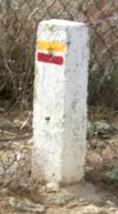
Walk directions: Walk up past the Restaurant Foz Do Banho and at the roundabout turn left . Walk down the cobbled road and turn left at the marked caminho (trail) sign.(Markings are parallel lines in orange and red). At the bottom of the hill, (point A) cross the stream and turn immediately left, ignoring the marked track going uphill on right. Follow the path near the river, it will become a narrow path, keep to the right track and follow the small path up to the top of the hill.
At the top of the hill turn right and follow this wide track, climbing up the hill for quite a distance. Ignore the marked caminho sign on the right.
After a few more hundred yards, take the next left turn at a turning marked with an X ( a crossed orange and red sign) and head down. Keep to the right track. At a T junction turn immediately hairpin left. This is marked with a pink/blue bow and a pile of stones. Follow the slightly overgrown path, bearing right, where it forks left up a rise to some beehives.
After approximately 15 minutes turn left, almost doubling back on yourself where you see the pink /blue bow and the pile of stones, along a path that is a bit overgrown.
Eventually you return to the first path( about 100m from the T junction referred to above) where you need to turn sharp right. Walk back along the original route and back up to the wide caminho track ( the one with the multi coloured X) where you should turn right. Follow this wide track to the next left turn and follow the caminho route back down the hill, ( reaching point A, see above) go across the stream and up the other side, then right back up the cobbled road to the start
Eating: Foz do Banho is recommended ( closed Monday), as is Cafe Imperio (closed Tuesday) about 1k further up the road towards Monchique ( it’s on the left, easily missed, but only does a v good chicken piri-piri). Alternatively, Rasmalho has a cafe/restauarante Riba E Serra , about 7km back towards Portimao that has a good prate de dia for about 8€ ( Closed Saturday).


